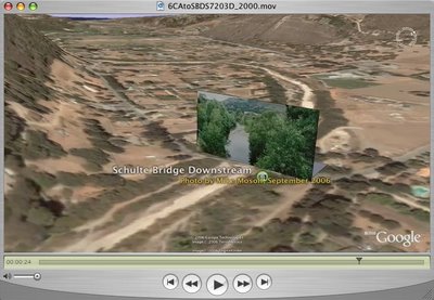
 Click on the image or this link to view this High Definition video with a window size of 1280 x 720 from Blip.tv This is the same video I posted yesterday that was viewable in a 720x405 window size. It is a Google Earth Fly in to a simple verticle billboard photograph recently taken showing a downstream view from the Schulte Bridge on the Carmel River. Successful riparian restoration efforts starting in the 1980s are very visibile in the plush tree growth on both sides of the river in the photograph.
We have started a Carmel River Wiki Spaces project where people can discuss issues and submit stories and photographs representing restoration efforts on the river.
No comments:
Post a Comment